
Dar es Salaam Grew More Than 100 Times, but Its Infrastructure Never Kept Pace
Ready
Dar es Salaam has grown from approximately 69,000 residents in 1948 to an urban area exceeding eight million in 2026, transforming a colonial port into Tanzania's largest commercial centre. Successive governments built railways, expanded roads and introduced East Africa's first bus rapid transit system, which initially cut journey times by more than half. Yet approximately 70% of the city's residents live in unplanned areas, and congestion, flooding and inadequate services continue imposing substantial costs on businesses and households. The city's history demonstrates how infrastructure investment has struggled to match the scale and speed of urban growth.
Dar es Salaam has grown from a coastal city of approximately 69,000 people in 1948 to an urban area exceeding eight million in 2026, becoming one of Africa's largest commercial centres. Over that period, successive governments developed railways, expanded roads, invested in drainage and introduced East Africa's first bus rapid transit system. Yet much of the city's residential development remains unplanned, transport infrastructure struggles to accommodate demand, and residents continue losing productive hours to congestion. The history of Dar es Salaam demonstrates how substantial infrastructure investment can coexist with an urban economy whose growth has consistently exceeded the capacity of its planning institutions.
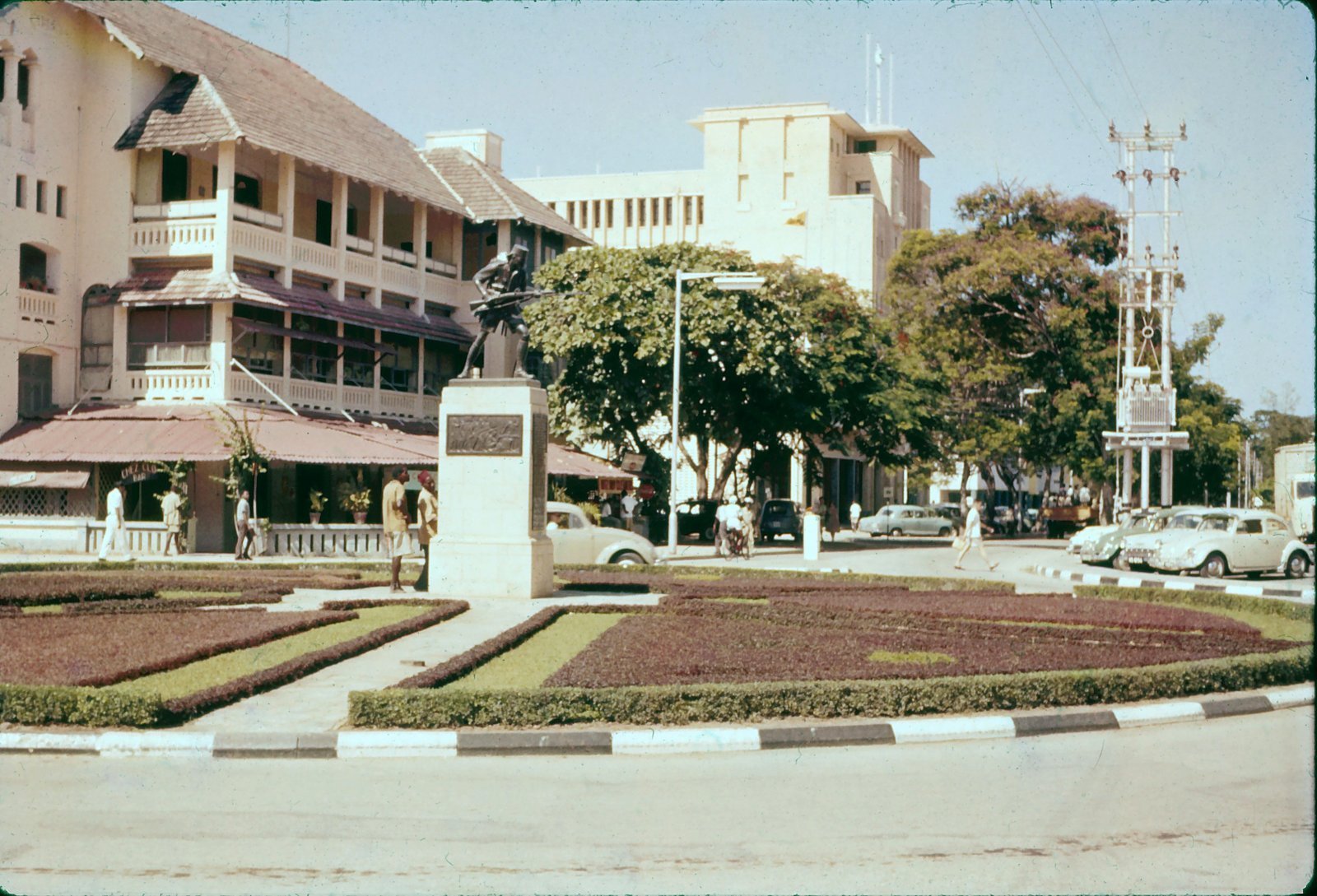
East Africa's largest and 7th largest coastal city in Africa, Dar es Salaam has undergone one of the most extensive urban transformations in East Africa, expanding from a relatively small colonial port into a metropolitan economy accommodating millions of residents, major industrial establishments, financial institutions and Tanzania's principal international maritime gateway. Historical census records place the city's population at approximately 69,227 in 1948 and 128,742 in 1957, shortly before Tanganyika gained independence. By 1967, the population had reached 272,821, and subsequent migration, natural population growth and the expansion of residential development transformed the city into Tanzania's largest concentration of economic activity. United Nations urban area estimates indicate that the wider built up settlement exceeds eight million residents in 2026, more than 100 times the population recorded in 1948, although the two estimates cover geographic areas that have changed considerably over time.
The scale of growth becomes clearer when compared with the infrastructure that successive administrations expected the city to require. Dar es Salaam's first comprehensive master plan, prepared in 1948 and generally referred to as the 1949 plan, envisaged a city of approximately 200,000 residents. That population threshold was surpassed during the first decade of independence, as restrictions on migration were removed and growing numbers of Tanzanians moved to the commercial capital in search of employment, education and business opportunities. Additional master plans were prepared in 1968 and 1979, but their implementation was constrained by limited financial resources, institutional changes and the pace at which people were settling beyond formally planned areas. By the time infrastructure intended for one stage of growth was developed, the city's population and geographical footprint had already expanded further.
Dar es Salaam's experience provides a useful examination of the relationship between economic growth, public investment and the capacity of urban institutions. The city has benefited from important transport and infrastructure projects, including the Central Railway, the Tanzania Zambia Railway, major road improvements, port expansion and the Dar Rapid Transit system. These investments have improved connectivity, supported trade and expanded access to essential services. However, infrastructure development has frequently followed the establishment of residential neighbourhoods and commercial activity rather than preceding them, requiring authorities to introduce roads, drainage, public transport and other services into areas that were already densely occupied.
The consequence is an urban economy in which infrastructure improvements continually confront demand generated by previous decades of population growth. Expanding road capacity can reduce travel times along a particular corridor, but the benefits diminish when housing, employment and commercial activity continue spreading across areas with limited connections to public transport. New electricity and water connections improve household conditions, yet the cost of extending these services increases when settlements have developed without reserved infrastructure corridors. Dar es Salaam's central economic challenge is consequently related to the timing, coordination and financing of investments needed to support a rapidly expanding city.
Colonial Planning Established a City Divided by Race and Access to Infrastructure
The origins of Dar es Salaam's urban structure can be traced to the colonial period, when infrastructure investment and land use regulations were shaped by the administrative and commercial priorities of German and British authorities. The Germans developed the city as a port and administrative centre, constructing roads and railway connections intended to support trade between the coast and the interior. The city's early planning framework also divided residential areas according to building standards that closely followed racial categories, with European, Asian and African communities occupying different parts of the settlement.
The German building ordinance introduced in 1891 established three zones with different construction requirements. Areas near the waterfront were reserved for buildings constructed to higher standards, while other districts allowed different materials and forms of development. The arrangements reflected colonial assumptions about the status of different communities and influenced where public services, permanent buildings and commercial infrastructure were concentrated. British authorities subsequently maintained and developed these spatial divisions, incorporating them into urban planning regulations and the city's postwar master planning arrangements.
The consequences extended beyond residential segregation. Areas occupied by wealthier residents and commercial institutions received greater investment in roads, drainage, sanitation and public services, while African settlements developed with more limited infrastructure. Neighbourhoods such as Kariakoo evolved within this uneven urban structure, combining commercial activity with dense residential settlement. The distinction between planned areas and settlements with inadequate services became an enduring feature of the city's geography.
The 1949 master plan continued to organise development through differentiated residential areas and land use arrangements, even as the city was approaching independence. Its assumptions about future population growth and the resources available for infrastructure reflected a comparatively small urban centre. When Tanzania became independent in 1961, the government inherited a functioning port, railway connections and established commercial districts, but also an urban structure designed around colonial priorities and a population that was expanding beyond the capacity anticipated by earlier plans.
Independence fundamentally changed access to the city. The removal of colonial restrictions on movement allowed more Tanzanians to seek economic opportunities in Dar es Salaam, accelerating migration from rural areas and other parts of the country. The city's population increased rapidly, while the government faced competing demands for public investment in education, healthcare, agriculture, national transport infrastructure and urban services. Dar es Salaam remained the country's principal commercial centre even as national policy encouraged rural development and later pursued the relocation of government functions to Dodoma.
The historical significance of colonial planning lies partly in the physical structure that continued shaping the city's expansion. Roads originally designed to connect the waterfront with areas outside the colonial centre evolved into major urban transport corridors. Residential development increasingly followed routes such as Morogoro Road, Bagamoyo Road, Pugu Road and Kilwa Road, creating long stretches of urban settlement dependent on a limited number of main transport connections. This pattern remains relevant to the economic geography of Dar es Salaam because many residents continue travelling considerable distances between affordable housing, employment centres and major commercial districts.
Tanzania Built Railways and Modern Transport, but the City Expanded Faster
Tanzania's infrastructure history demonstrates considerable capacity to develop complex transport projects. The Central Railway connected Dar es Salaam with inland production centres and helped establish the city as a principal outlet for agricultural commodities and other goods. Following independence, the construction of the Tanzania-Zambia Railway introduced another major transport connection linking the Port of Dar es Salaam with Zambia and the wider Southern African region. The 1,860-kilometre railway was completed in 1975, with full operations beginning in July 1976 following its formal handover by China to Tanzania and Zambia.
TAZARA represented a major engineering and geopolitical achievement, creating a transport route through difficult terrain and providing Zambia with an alternative connection to international maritime trade. Its construction required extensive bridges, tunnels and earthworks and involved tens of thousands of Tanzanian, Zambian and Chinese workers. For Dar es Salaam, the railway reinforced the city's role as a regional commercial gateway, supporting freight movements between the Indian Ocean and inland markets.
However, national freight infrastructure and urban mobility serve different economic requirements. Railways connecting ports with distant markets strengthen trade and industrial activity, but residents still require affordable transport between their homes, workplaces, schools and commercial centres. As Dar es Salaam expanded through the 1970s, 1980s and subsequent decades, its public transport system increasingly depended on daladala minibuses operating along congested roads, while residential development extended beyond the areas adequately served by formal urban infrastructure.
The introduction of the Dar Rapid Transit system in May 2016 represented a substantial response to that challenge. Tanzania became the first East African country to operate a modern bus rapid transit system, establishing dedicated bus corridors intended to move large numbers of passengers more efficiently through the city. The first phase covered approximately 20.9 kilometres and introduced a transport service designed to reduce the journey times experienced by commuters travelling along major routes into the central business district.
According to the Institute for Transportation and Development Policy, the system began operating with approximately 140 buses and initially served around 200,000 passengers each day. Travel times along the first corridor fell by more than 50%, demonstrating the economic value of dedicated public transport infrastructure in a city where conventional vehicles and minibuses were frequently delayed by congestion. The World Bank subsequently reported that more than four million passengers had benefited from the system through an average reduction of approximately 24 minutes in transit time.
These improvements have direct consequences for productivity. Time spent travelling to work reduces the hours available for employment, education, household activities and rest. For businesses, unreliable commuting can influence employee attendance, delivery schedules and the effective size of the labour market from which workers can be recruited. A transport system that reduces journey times can therefore generate economic benefits beyond its fare revenue by improving access to jobs and commercial opportunities across the city.
Yet the system's operating challenges emerged as demand increased. The Institute for Transportation and Development Policy documented overcrowded buses and stations, insufficient services outside peak periods and irregular bus arrival intervals, attributing several problems to an inadequate operating fleet. The organisation also identified weaknesses in the original operational arrangements and financial pressures affecting the service provider. The difficulties demonstrated that constructing dedicated bus lanes and stations represented only one component of the investment required to operate a high capacity urban transport service.
The financial and operational model needed to support sufficient buses, maintenance, scheduling and service management was equally consequential. Without an adequate fleet, the infrastructure could not consistently deliver the passenger capacity for which it was designed. This distinction is relevant to other major infrastructure projects in Tanzania because the completion of physical assets does not automatically establish the institutional and financial arrangements necessary to operate them efficiently over time.
Seven in Ten Residents Live With the Consequences of Unplanned Development
The scale of unplanned residential development is one of the clearest indicators of the difference between Dar es Salaam's population growth and its planning capacity. A 2024 Tanzania National Roads Agency report, cited in a subsequent assessment of the city's bus rapid transit expansion, estimated that approximately 70% of residents lived in unplanned areas. The World Bank has similarly reported that roughly 70% of urban development occurred informally and without the accompanying extension of essential services. The estimates reflect a longstanding problem that has shaped housing, transport, drainage and land administration across the city.
Unplanned settlements accommodate a substantial share of Dar es Salaam's workforce and economic activity. They include established neighbourhoods containing permanent houses, markets, workshops, schools, religious institutions and other facilities that have developed through private investment by households and businesses. Their classification as unplanned does not imply an absence of economic value or social organisation. Many communities provide housing that is more affordable than formally developed alternatives and allow residents to live within reach of employment and commercial opportunities.
The economic difficulty arises when residential development proceeds without adequate roads, drainage, public transport corridors and utility infrastructure. Retrofitting these services can require demolition, land acquisition, relocation, changes to existing property boundaries and expensive construction works. Roads that would have been relatively inexpensive to reserve before an area became densely populated can become difficult to establish once houses and businesses occupy the required land. Drainage infrastructure faces similar constraints when natural waterways have been obstructed by buildings and other development.
The problem is particularly evident in Dar es Salaam's flood prone areas. The city is situated on low lying coastal terrain with rivers and drainage systems affected by seasonal rainfall and changes in land cover. As residential development expands into areas with inadequate drainage, flooding can damage housing, disrupt transport, destroy business inventories and reduce household income. The World Bank estimated that severe flooding in 2018 caused approximately $100 million in economic losses to households, equivalent to around 2% of the city's GDP at the time.
These costs illustrate how urban planning influences economic performance. Flooding can interrupt commercial activity, prevent workers from reaching their workplaces and damage infrastructure that subsequently requires public expenditure for repairs. Businesses operating in vulnerable locations may face higher insurance costs or absorb losses directly when coverage is unavailable. Households may also lose savings invested in housing, equipment and merchandise, reducing their capacity to finance education, healthcare and future business activities.
Tanzania has undertaken substantial investments to address these conditions. Between 2015 and 2023, the World Bank supported Dar es Salaam Metropolitan Development Project improved more than 207 kilometres of urban roads and associated drainage, pedestrian facilities and street lighting, benefiting more than four million people. The programme also upgraded infrastructure in lower income neighbourhoods and improved flood protection in selected areas. These investments demonstrate that upgrading established settlements can generate tangible improvements in mobility, safety and access to services.
However, upgrading existing neighbourhoods is considerably more demanding than providing infrastructure before settlement occurs. The city must simultaneously maintain established roads and drainage systems, address deficiencies in older neighbourhoods and extend infrastructure to areas experiencing new residential and commercial development. This creates continuing pressure on public budgets and the capacity of municipal institutions to plan, finance and manage urban growth.
Dar es Salaam's Infrastructure Deficit Has Become a Productivity Cost
The economic consequences of inadequate urban planning extend into the daily operating costs faced by residents and businesses. Dar es Salaam serves as Tanzania's principal financial and commercial centre, accommodates major manufacturing and trading activities and handles substantial volumes of imports and exports through its port. Its economic importance means that weaknesses in the city's transport and infrastructure systems affect commercial activity beyond the administrative boundaries of Dar es Salaam itself.
The World Bank has estimated that average public transport commuting times in Dar es Salaam can reach approximately 120 minutes each way, creating substantial losses of time for residents travelling between their homes and workplaces. A commuter spending four hours travelling each working day loses a considerable part of the day to movement rather than income generating activity, education or household responsibilities. For low income workers, commuting expenses can also absorb a meaningful share of earnings, particularly where employment opportunities are concentrated in locations far from affordable residential areas.
Congestion imposes costs on businesses through delayed deliveries, additional fuel consumption, vehicle maintenance and the unpredictable movement of workers and goods. Freight operators serving the Port of Dar es Salaam must coordinate maritime cargo handling with inland transport, while manufacturers and retailers depend on reliable distribution to maintain inventories and serve customers. Delays on urban roads can therefore influence the cost of imported merchandise, industrial inputs and other goods distributed through the country's largest commercial market.
The expansion of Dar es Salaam Port has further increased demand for logistics land, container depots, truck parking and freight corridors. This is visible in plans to accommodate additional port related activities in Temeke Municipality and continuing investment in facilities such as Kwala Dry Port in the Coast Region. The decisions concern more than freight handling capacity because commercial logistics facilities compete with residential and other land uses for space near the port and major transport corridors.
The city's transport economy consequently requires coordination between several forms of infrastructure. Port development influences demand for inland freight transport, while residential expansion affects public transport requirements and road congestion. Industrial development creates demand for electricity, water, housing and commercial services. Where these investments are planned separately, improvements in one area can generate pressure elsewhere, reducing the economic benefits of the original investment.
The cost of urban expansion is also influenced by the physical pattern of residential development. Lower density settlements extending across a wide geographical area require longer roads, electricity lines, water pipes and transport routes to serve the same number of people. Higher density development can reduce the length of some infrastructure networks per household, but requires sufficient capacity in water, sanitation, drainage and public transport to accommodate concentrated demand. Efficient urban development therefore depends on matching land use, residential density and infrastructure investment to the capacity of the institutions responsible for delivering services.
The Next Phase of Urban Growth Requires Infrastructure Before Settlement
Dar es Salaam's planning history demonstrates that the challenge has been recognised repeatedly. Master plans prepared in 1949, 1968 and 1979 attempted to establish frameworks for urban growth, industrial activity and infrastructure provision. The 1979 plan envisaged stages of expansion towards a city of approximately 2.4 million people, a population that Dar es Salaam subsequently exceeded as urbanisation continued. Later efforts to develop strategic planning frameworks also faced institutional and implementation difficulties.
The gap between planning and implementation has several economic causes. Urban infrastructure requires substantial upfront expenditure, while the benefits are often realised over many years through improved mobility, higher land values, greater business productivity and reduced operating costs. Local authorities may lack the revenue required to provide roads, drainage and essential services at the pace demanded by population growth. Land acquisition, fragmented responsibilities and changing government priorities can further delay implementation.
The financial challenge becomes greater when infrastructure is introduced after development has occurred. Compensation, relocation and demolition costs increase project expenditure, while established residential and commercial activities make it more difficult to reserve space for roads and transport corridors. The government consequently faces the cost of correcting older deficiencies while financing infrastructure for new settlements that continue expanding at the urban periphery.
Dar es Salaam's experience suggests that the provision of planned and serviced land should be treated as an economic investment rather than solely an administrative function. Reserving transport corridors, establishing drainage networks and making land available for residential and commercial development before dense settlement occurs can reduce future construction costs and improve the ability of businesses and households to access essential services. This also requires systems through which land use decisions, infrastructure finance and property development are coordinated across municipal boundaries.
Public transport investment will remain central to this process because the size of Dar es Salaam makes it increasingly difficult for road expansion alone to accommodate rising travel demand. The BRT experience demonstrates that dedicated corridors can achieve substantial reductions in commuting times, but also shows the importance of financing vehicle fleets, maintaining equipment and managing service frequency. Extending rapid transit into additional areas can improve accessibility where investments are supported by sufficient operating capacity and connections with existing transport services.
Railway infrastructure also has a role in shaping the city's future development, particularly through the movement of freight away from congested urban roads and the connection of industrial areas with inland logistics facilities. However, the economic benefits depend on coordination between railway operations, ports, container depots and road transport. New infrastructure must be accompanied by institutions capable of managing the services it is intended to provide.
Dar es Salaam has already demonstrated that large infrastructure investments can be undertaken. The construction of TAZARA, development of major roads, improvement of port facilities, introduction of bus rapid transit and upgrading of informal settlements have all expanded the city's economic capacity. The record also demonstrates the cost of providing these investments after rapid population growth has established demand far beyond the original capacity of the infrastructure.
The city's population has grown from approximately 69,000 in 1948 to more than eight million across the wider urban area in 2026. During those decades, its residents created businesses, neighbourhoods and commercial markets that made Dar es Salaam Tanzania's principal economic centre. The infrastructure serving that economy expanded, but often after households and businesses had already absorbed the costs of inadequate transport, drainage and public services.
The next stage of Dar es Salaam's development will depend on whether infrastructure planning can begin to anticipate population growth rather than respond to its consequences. The financial benefits would extend beyond better roads and shorter commutes into lower business operating costs, more productive employment, improved access to land and greater efficiency across Tanzania's largest urban economy.
FAQ
How many people live in Dar es Salaam in 2026? Tanzania's National Bureau of Statistics projects approximately 6.0 million residents within Dar es Salaam Region in 2026. Broader urban area estimates exceed eight million because they use different geographical boundaries.
What was Dar es Salaam's population before independence? Historical census records show approximately 69,227 residents in 1948 and 128,742 in 1957, before Tanganyika gained independence in 1961.
How much has Dar es Salaam grown since 1948? Comparing the historical 1948 city population with the wider 2026 urban area estimate gives an increase exceeding 100 times, although the geographical areas measured differ.
When was Dar es Salaam's first master plan developed? The city's first comprehensive master plan was prepared in 1948 and is generally referred to as the 1949 master plan. It envisaged a city of approximately 200,000 residents.
When did Dar es Salaam introduce bus rapid transit? The Dar Rapid Transit system began operations on May 10, 2016, becoming East Africa's first operational bus rapid transit system.
How much did BRT reduce commuting times? The Institute for Transportation and Development Policy reports that the original BRT service reduced journey times by more than 50% along its first corridor and initially served approximately 200,000 passengers daily.
How many Dar es Salaam residents live in unplanned settlements? A 2024 TANROADS assessment cited in reporting on the city's transport development estimated that about 70% of residents lived in unplanned areas.
Why does Dar es Salaam experience persistent traffic congestion? Rapid population growth, residential expansion beyond established infrastructure, concentration of employment and commercial activities, inadequate transport capacity and the movement of freight through urban roads contribute to congestion.
What infrastructure projects have improved Dar es Salaam? Major investments include railway connections, port development, road expansion, the BRT system and the Dar es Salaam Metropolitan Development Project, which upgraded more than 207 kilometres of urban roads and supporting infrastructure.
 Uchumi360
Business Intelligence
Uchumi360 covers business, investment, and economic policy across East, Central, and Southern Africa.
For the serious reader
You read to the end. That places you in a small group.
Uchumi360 is built for readers who demand precision over speed, structure over sentiment, and analysis that holds uncomfortable conclusions rather than softening them. If this work sharpens how you think about Africa's economy, help us keep building the infrastructure behind it.
Institutional Partners
Commission intelligence. Shape the conversation.
Uchumi360 works with development finance institutions, investment firms, sovereign bodies, and strategic organisations across the coverage region. Institutional partnership unlocks:
- Commissioned sector and country intelligence reports
- Branded research series under your institution's authority
- Exclusive data briefings for internal strategy teams
- Speaking and editorial presence at Uchumi360 events
- Co-published investment outlooks for your markets
Support Our Work
Independent analysis has a cost. Help us bear it.
Uchumi360 does not carry advertising. It does not take editorial direction from sponsors. Every article is produced without commercial compromise. Your contribution funds the reporting, research, and editorial infrastructure that keeps this analysis free from influence.
Secure checkout: One-time and monthly support are processed securely. Add payment credentials to enable checkout here.
Stay Connected
Keep up with every new insight.
Follow our latest analysis, policy coverage, and market intelligence as soon as it is published. If you need something specific, reach out directly and we will point you to the right research.
