Dar es Salaam Is Getting USD 385 Million in Urban Infrastructure. The Most Important Line Item Is USD 28 Million Nobody Is Talking About.
The World Bank's International Development Association approved a USD 350 million credit for the Dar es Salaam Metropolitan Development Project Phase II in December 2023, complemented by a USD 30 million Netherlands grant for solid waste management and USD 5 million in Tanzanian government counterpart funding. The total package of USD 385 million, approximately TZS 1.2 trillion, will tarmac over 250 kilometres of roads, build 100 kilometres of drainage infrastructure, and construct modern waste transfer facilities. These are the numbers that will generate headlines. The number that will determine whether Dar es Salaam can sustain what this investment builds is USD 28.3 million allocated to institutional strengthening, specifically to a GIS-based property tax system that could transform how Tanzania's largest city finances itself.
The Package and Its Architecture
DMDP II is structured as a World Bank IDA credit operation, the financing instrument available to lower-income countries on concessional terms, supplemented by a Netherlands bilateral grant targeted specifically at the solid waste management component. The funding architecture reflects a deliberate division of labour: the IDA credit finances the infrastructure investment whose returns are diffuse and long-horizon, the Netherlands grant finances the environmental public good of waste management whose benefits are immediate and health-related, and the government's counterpart funding, modest at USD 5 million, signals political commitment without stretching a fiscal position that Tanzania's B+ sovereign rating reflects is already constrained.
The component breakdown reveals the investment priorities with specificity that aggregate figures obscure. The largest single allocation, USD 256 million, goes to climate-smart infrastructure covering the tarmacking of over 250 kilometres of roads, 100 kilometres of storm-water drainage, and solar street lighting across the project zones. The solid waste component receives USD 50 million for modern transfer stations and the Mgeni-Mmoja landfill development. Project management and oversight absorbs USD 15.7 million. And USD 35 million is held as a contingency emergency response fund, re-allocatable to immediate disaster or flood response without requiring new project approval cycles.
The geographic distribution of road contracts already signed under DMDP II reveals the spatial logic of the investment. Ilala, the commercial core, has committed TZS 138 billion to 56.12 kilometres of road upgrades including the Kivule-Majohe Junction and Kitunda-Msongola routes that serve as bypass infrastructure for the Julius Nyerere International Airport corridor. Temeke, the industrial zone adjacent to Dar es Salaam Port, is receiving TZS 97.1 billion across 51.2 kilometres of roads targeting logistics cost reduction for port-adjacent industries. Kigamboni and Ubungo together are receiving contracts exceeding TZS 70 billion for a combined 31 kilometres of upgrades focused on unlocking residential and commercial density in zones that currently suffer from the accessibility constraint that keeps land values below their potential.
This geographic distribution is not arbitrary. It reflects a specific theory of urban economic development: connect the port to its industrial hinterland, connect the airport to the commercial centre, connect high-density residential zones to employment corridors, and the aggregate productivity gain from reduced transport friction should exceed the sum of the individual route improvements. The theory is sound. The execution is what will determine whether the theory produces the projected outcome.
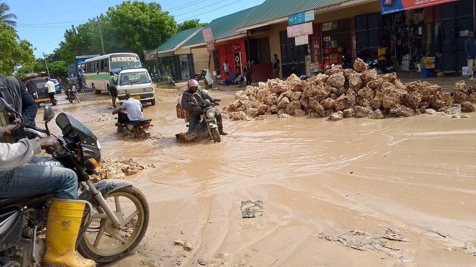
The Flood Problem That USD 2 Billion Buys
The World Bank's project documentation includes an estimate that Dar es Salaam loses up to 2 percent of its GDP annually to flood-related disruptions. At Tanzania's current GDP scale, 2 percent represents a substantial annual economic loss from a single source of infrastructure vulnerability that is both predictable and partially addressable through engineered drainage systems.
Dar es Salaam's flood vulnerability is structural rather than episodic. The city's topography, characterised by low-lying coastal zones, river valleys, and informal settlements built on flood plains that formal planning frameworks failed to prevent from being occupied, creates predictable inundation during the long rains season. The informal drainage systems that exist across much of the city's residential fabric were designed for smaller precipitation volumes than current climate conditions generate, and the encroachment of structures into natural drainage corridors has progressively reduced the city's capacity to move storm-water away from residential and commercial areas before it causes damage.
The 100 kilometres of storm-water drainage that DMDP II finances addresses a portion of this structural vulnerability across the project corridors. The drainage infrastructure is specifically described as climate-smart, reflecting the design philosophy shift that the TANROADS programme also identified: building infrastructure to future climate projections rather than historical baselines. A drainage system designed for the rainfall intensities of the 1990s will underperform in the precipitation environment that climate projections indicate for Dar es Salaam in the 2030s and 2040s. A system designed to climate-smart standards incorporates that trajectory into its hydraulic calculations.
The USD 35 million emergency response contingency fund built into the project structure is a design innovation that addresses the gap between infrastructure investment cycles and climate event timelines. Major World Bank infrastructure projects typically require lengthy reappraisal and approval processes before funds can be redirected to emergency response. The CERC mechanism, contingency emergency response component, allows pre-approved fund reallocation for immediate disaster response without the full project restructuring process. For a city that experiences major flood events with increasing frequency, the ability to mobilise infrastructure repair financing within weeks rather than months has direct economic value in the form of reduced recovery time for the commercial and residential zones that flooding disrupts.
The USD 28 Million That Could Change Everything
The institutional strengthening component of DMDP II deserves substantially more analytical attention than its USD 28.3 million allocation suggests relative to the USD 256 million infrastructure component. Physical infrastructure depreciates. Institutional capability compounds. The roads built under DMDP II will require maintenance, rehabilitation, and eventual reconstruction over the next thirty years. Whether Dar es Salaam's municipal authorities can finance that lifecycle cost from domestic revenue or will remain permanently dependent on external financing for every subsequent investment cycle is the question that the institutional strengthening component is designed to answer.
The centrepiece of this component is a Geographic Information System for property taxation. Dar es Salaam has a property base whose market value is substantial and growing, driven by the population growth, commercial development, and infrastructure investment that the city has absorbed over the past two decades. Property in the city's established commercial zones commands values that generate significant capital gains for owners. Residential property across the metropolitan area represents a large and growing stock of private wealth.
The municipal revenue that should flow from this property base through property taxation is a fraction of its potential. The reasons are institutional rather than political. Without a comprehensive, current, and spatially accurate register of properties, their ownership, their use, and their assessed value, tax administration cannot function at scale. Properties that are unregistered cannot be taxed. Properties registered on outdated records are taxed on values that may be a fraction of current market rates. Properties in informal settlements are effectively outside the tax base entirely regardless of their market value or their owners' ability to pay.
The GIS property tax system addresses this at the foundational level. A spatial database that maps every property in the municipal area, records its physical characteristics, links it to ownership records, and provides the assessment tools to determine taxable value creates the administrative infrastructure for a municipal revenue system that is not dependent on central government transfers or external financing for its operating budget. Municipalities in Kinondoni and Temeke that can collect property tax revenues proportional to the actual property values in their jurisdictions become financially self-sustaining entities capable of financing their own maintenance and incremental infrastructure investment rather than supplicants for central government budget allocations.
The economic significance of this transformation extends well beyond municipal finance. A city that taxes its property base creates incentives for productive land use, discourages speculative land banking, and generates the fiscal revenue that finances the public goods, maintenance, waste collection, street lighting, and local road repair, that make property values sustainable rather than dependent on one-time infrastructure investment. The property tax system is the feedback mechanism that converts infrastructure investment into a self-reinforcing urban development cycle rather than a one-time external injection whose benefits erode as maintenance is deferred.
Phase II Versus Phase I: The Expansion of Scope
DMDP Phase I focused on core arterial roads, the primary corridors that connect major urban zones and carry the highest traffic volumes. Phase II deliberately shifts toward what the project documentation describes as the capillaries of the city, the secondary and tertiary roads that connect high-density residential zones to the arterial network.
This shift reflects an understanding of how urban productivity actually works that first-generation urban infrastructure programmes often miss. Arterial road investment reduces travel times between major origins and destinations. But the residents and businesses in high-density areas that are not directly served by arterialmroads capture limited benefit from arterial improvements if the last-mile connections from their locations to the arterial network remain unpaved, flooded during rains, or inaccessible to vehicles. The worker who lives 500 metres from a newly upgraded arterial road but on an unpaved street that becomes impassable during the rains does not experience the productivity improvement that the arterial investment was designed to deliver.
DMDP II's focus on 250 kilometres of secondary and tertiary road upgrades across Ilala, Temeke, Kigamboni, and Ubungo addresses precisely this last-mile gap. The productivity returns from connecting residential density to the arterial network are distributed more broadly across the population than the arterial investment itself, because the beneficiaries are the workers and small business operators in high-density zones rather than the commercial vehicle operators and long-distance commuters who primarily benefit from arterial improvements.
The interaction between DMDP II's secondary road programme and the BRT expansion that Uchumi360 analysed in detail creates the potential for a genuinely integrated urban mobility system. BRT provides high-capacity, high-frequency movement along primary corridors. DMDP II's secondary road upgrades provide the feeder connectivity that allows residents throughout the metropolitan area to access BRT stations without the last-mile barrier of unpaved, inaccessible streets undermining the trunk network's effectiveness. The two programmes are separately financed and separately managed, but their economic returns are partially dependent on each other's completion.
The Execution Risk That History Documents
Engineer Mlali's reference to encroachment compensation and utility relocation as causes of infrastructure delay is confirmed by the DMDP Phase I experience that the World Bank's own project documentation records. When road upgrades require the removal or relocation of informal structures, utility lines, or encroachments that have accumulated along road reserves over years of inadequate urban planning enforcement, the compensation, legal, and coordination processes consume time and resources that delay construction and increase costs beyond appraisal estimates.
Dar es Salaam's road reserves, the strips of land designated for road infrastructure that should be kept clear of permanent structures, have been progressively encroached upon across most of the city's secondary and tertiary road network over the past three decades. The density of encroachments reflects the planning enforcement failures that characterised rapid urban growth without adequate municipal capacity, and resolving them requires engagement with the affected communities, legal processes for legitimate occupants, and utility relocation coordination with TANESCO and DAWASA that each operate on their own institutional timelines.
The cost-overrun trap that the brief references is not hypothetical. It is a documented pattern in Tanzanian infrastructure projects where the gap between appraisal estimates and actual costs reflects both encroachment resolution costs and utility relocation costs that were underestimated at the project design stage. DMDP II's project management allocation of USD 15.7 million and the CERC emergency fund of USD 35 million provide some buffer against cost and timeline pressures, but neither addresses the root cause of encroachment-related delays, which is the need for more rigorous road reserve protection enforcement before project implementation begins rather than during it.
What DMDP II Means for Dar es Salaam's Economic Trajectory
Dar es Salaam's ambition to compete as a regional economic hub against Nairobi and to serve as the primary gateway for the Central Corridor's landlocked hinterland depends on the city functioning with the efficiency that hub status requires. A city where secondary roads flood seasonally, where solid waste accumulates in informal settlements without collection systems, and where municipal authorities cannot generate the revenue to maintain the infrastructure they receive from external financing is a city whose hub ambitions are structurally constrained regardless of its geographic advantages and its investment pipeline.
DMDP II addresses each of these constraints simultaneously and in a financing structure that is more sophisticated than standard infrastructure lending. The combination of road infrastructure, drainage, waste management, and institutional revenue system development within a single project framework reflects the World Bank's recognition that urban development challenges are systemic rather than sectoral, and that addressing roads without addressing drainage, or addressing infrastructure without addressing the municipal finance system that must maintain it, produces outcomes that underperform their potential.
The USD 28.3 million institutional strengthening component is the investment that will determine whether DMDP II is remembered as another infrastructure injection that required subsequent external financing to sustain, or as the investment that built Dar es Salaam's capacity to finance its own urban development from its own revenue base. The roads will be visible from day one of their completion. The property tax system will take years to demonstrate its returns. But in urban development economics, the fiscal capacity that municipal revenue systems provide is the variable that determines whether cities can sustain their infrastructure over the long horizon that urban investment requires.
Dar es Salaam has the population, the geography, and now the infrastructure investment to support its regional hub ambitions. Whether it builds the institutional revenue architecture to sustain that infrastructure is the question that the next decade will answer.
_____________________________________________________________________________________
Sources: World Bank International Development Association Project Appraisal Document Report No P171958, DMDP II, December 2023. United Republic of Tanzania PO-RALG Contract Signing Documentation May and June 2024. Daily News Tanzania DMDP II Roads Project Reporting. World Bank Project Component and Financing Documentation. Tanzania Investment and Special Economic Zones Authority Data 2025. Dar es Salaam City Council Municipal Revenue Data. TANESCO and DAWASA Utility Infrastructure Documentation. World Bank Urban Flood Risk and GDP Loss Estimation for Dar es Salaam. Data reflects information available to March 2026. Current project implementation status and contract awards should be verified against latest World Bank project portal and PO-RALG publications before final publication.
_____________________________________________________________________________________
Uchumi360 covers business, investment, and economic policy across East, Central, and Southern Africa.
